The Project will be conducted with the collaboration of the University of Cadiz, Spain, and specially with the Unit of Geodetection, Analysis and Georeferenciation of Historical and Cultural Heritage, belongs to the IVAGRO, Wine and Agrifood Research Institute, managed by Prof. Lázaro Lagostena.
This Project is supported by a Marie Curie fellowship, granted by the European commission within the actions Horizons 2020. Grant nª 798529. H2020MSCA-IF.
Abstract:
The lacus Ligustinus was the great paleo-estuary of ancient Baetis or current Guadalquivir river (Southern Spain). It is a radically transformed landscape because of the intensive sedimentation and other geomorphological dynamics. The estuary banks were highly populated during the Roman period. Important cities and towns articulated the surrounding rural settlement, dedicated to the agricultural and livestock activities. In addition, the lacus allowed the connection with the maritime routes and the output of products destined to foreign markets. Nowadays this spatial configuration is difficult to restore, especially the exploitation villae settlement patterns. The main purpose of the project is to devise a methodology applicable to the study of the paleo-banks through the identification of archaeological sites. In that sense, the right border of the current Lower Guadalquivir region has been selected as a delimited study area, and particularly a local region of Cadiz province. The historical diachronic evolution will be analysed through the archaeological evidences. In order to achieve this, geomorphological, archaeological and other historical data from this area will be integrated in a GIS. Then survey methodology, such as geophysical survey, and UAV flights applications, will be applied in the local scale considering it as a continuum area, to detect archaeological sites employing non-invasive prospection techniques. We will apply this methodology through the selection of a series of study cases. The project will be carried out in the Laboratory of Landscape Archaeology & Remote Sensing (LAP&T) at University of Siena. This laboratory is specialised in survey and integral analysis of ancient landscapes. There the candidate will be trained in the application of these techniques in order to acquire skills for the interpretation of the collected data.
Introduction:
During ancient times, the southern Iberian Peninsula was incorporated into the Roman Empire and the Hispania Baetica province was established in the late first century BC. Baetica was rich in resources such as metals, oil and wine and there were many towns and cities which controlled an intensive exploitation of their territories through the villae systems. The goods they produced were exported through the main fluvial route, the Guadalquivir River or Baetis which spanned this great area. This river was the main communication route of the province and consequently became the focus of many civic settlements. The mouth of the river was an estuary, a large coastal lake known as lacus Ligustinus in Late Antiquity. Nowadays it is transformed, as a result of the silting up effects and geomorphological changes which occurred in the depressionary area of the Atlantic coast of Andalusia (Spain). Most of the area is now marshland and predominantly part of the National Natural Park of Doñana. Riverbanks and shorelines have been defined as spaces which incorporate particular biological and ecological characteristics. They are an ecosystem located in zones of land-water interaction, susceptible to geomorphological changes and climatic variations, so-called riparia by Ecology. This concept has been applied to the study of the settlements, usages, management and perceptions of banks during the Roman Empire. This approach considers these ecosystems as integrated spaces where they could develop a certain interaction between the society and the environment. From this chronological, geographic and conceptual framework, the project aims at investigating the historical settlement pattern that has developed the landscape configuration on the banks of lacus Ligustinus. Rural settlements located in its paleo-banks were dedicated to farming, and the subsequent processing and export of agricultural products. Furthermore, there is archaeological evidence of a viticulture exploitation in this territory. Moreover, the proximity of archaeological sites on the river banks played a role as an enabler of fluvial-maritime communications, oriented toward the export of the products to the Mediterranean markets. The identification of these archaeological remains allows us to propose the restitution of paleo-banks, in agreement with geomorphological and geographical studies also being carried out. This project also expects to demonstrate an intensive occupation of this land. Archaeological excavations are often difficult to perform, expensive, hard time-consuming and a large process.
Consequently, the Investigator Principal (IP) proposes to design and apply a method to identify and analyse these archaeological landscapes using non-invasive techniques, such as remote sensing techniques on different scales. This methodology will be designed in the University of Siena’s Laboratory of Landscape Archaeology & Remote Sensing (LAP&T), as they are specialists in the study of archaeological landscapes through the application of new methodological approaches. This methodology is necessary to open up new historical approaches to the analysis of the Roman settlement patterns and its diachronic evolution on the paleo-estuary. In addition, the research work will allow the IP to become an international expert in the application of these archaeological survey techniques and trained in the post-processing and interpretation of complex data.
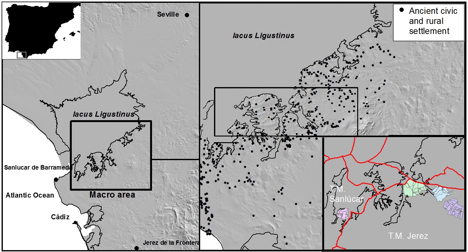
Study area at different scales
Objetives:
The main objective of this project is the integral study and the reconstruction of the roman settlement patterns and their diachronic evolutionary development along the riverbanks of the paleo-estuary. This reconstruction will be made in connection with the environmental changes taking place in this transformed landscape. A methodology of various applications of archaeological survey techniques, such as remote sensing and so called “traditional” techniques will be developed and put it into practice in different scales of analysis to achieve this objective.
RO1. To examine the historical settlement and environmental transformation produced in the ancient riverbanks of lacus Ligustinus for a long term diachronic perspective. The historical reading of landscape as a whole and its transformation through the large scale survey integrated in all previous works and knowledge.
RO2. To focus, during the residence at Siena, on archaeological analysis and GIS-databased interpretation in a multiscale landscape context, to integrate the data-collection into the previous historical debate and knowledge. This methodological strategy has been applied in LAP&T and carried out in the Tuscany region and we will now apply it in another zone, influenced by the Mediterranean region but situated in an Atlantic facing region.
RO3. To improve a methodology developed by the LAP&T through the application of new technologies. The diachronic changes in the landscape articulation through the protohistoric period, the important classical settlement pattern and the evolution in the medieval era and early modern period, in accordance with the environmental changes in a transformed landscape will be detected through the application of the LAP&T’s methodology designed.
RO4. To apply the previous experience of the supervisor and LAP&T team in their research in the Tuscany region and other parts of Mediterranean area, and the methodological proposal developed in the previous European project, to other historical contexts in the mediterranean area through the application of new survey techniques, especially UAV-base methods and GPR in large scale analysis.
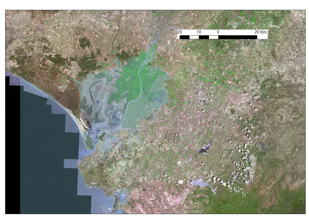
Ortophoto of Lower Guadalquivir, the blue shape point out the ancient flood lands.